Hiking
Hudson Vally Hikes: Mount Beacon Fire Tower Out-and-Back
Mount Beacon, located along the Hudson River about 90 minutes north of the city, offers one of my favorite hikes in the Hudson Valley. It’s not the longest, highest, nor […]
 Sakmann News, Entertainment and Sports
SNES Blog Network
Mount Beacon, located along the Hudson River about 90 minutes north of the city, offers one of my favorite hikes in the Hudson Valley. It’s not the longest, highest, nor […]
Mount Beacon, located along the Hudson River about 90 minutes north of the city, offers one of my favorite hikes in the Hudson Valley. It’s not the longest, highest, nor most difficult mountain to scale in the area, but the beautiful views and interesting scenery make for a lovely day for hikers of all ages and abilities.
Note: This is NOT intended to be a true hiking guide, but rather a recollection of my hike. While some parts may be informative and provide directions, I would recommend Hike the Hudson Valley.com for detailed turn-by-turn instructions.
Hiked on July 31, 2020
Mount Beacon is the main ascent route on the northern end of Hudson Highlands state park, which features multiple trail heads on Route 9D spanning from Beacon to Cold Spring. Heading further down Route 9D allows hikers to access the Breakneck Ridge trailhead, a popular and often crowded destination.

Breakneck Ridge is often one of the focal points when my friends and I hike the Hudson Highlands, completing hikes of 12-14 miles. But on this afternoon, I was looking for a shorter hike that still offered great views and a little bit of difficulty.
I loaded up before my hike with some coffee and an “Elvis Presley” (a peanut butter and banana sandwich.) The drive from my house to the Scenic Hudson parking lot is about 40-45 minutes, crossing over the Newburgh-Beacon bridge from West to East.
While I still felt a little tired in both the body and mind before the hike, getting out there and climbing up the mountain on a nice day ultimately helped me feel a lot better.

From the parking lot, the Casino Trail winds back and forth up to the mountain, culminating in a pretty sweet view (Beacon Overlook) that can be reached by even average hikers in about than an hour. I completed the initial ascent (1.0 miles, about 1000 feet of elevation gained) in 30 minutes: a personal-best for me but a number I still think I could improve on.
From there, the Mount Beacon Fire Tower is an additional 1.4 miles up the trail, but with less than 400 feet of elevation gain required. The meat of this hike is the first mile, featuring steepness that rivals other strenuous sections of Hudson Highlands State Park.
Google estimates the path from the parking lot to fire tower to be 1.8 miles, with 1,385 feet of elevation gain. I’m not sure where the disparity in distance comes from, but i measured about 2.25 miles each way (4.5 miles round-trip,) with roughly 1,130 feet in elevation gain. However, the difference in elevation from the parking lot (210 feet) to the fire tower (1,580 feet) resulted in a net gain of 1,370 feet, more in line with Google’s estimate.


The trail starts with a short gravel path before a unique feature: a staircase that quickly jump-starts the elevation gain. About 200 stairs precede hiking on the natural terrain, which remains a steady incline until the Beacon Overlook/Casino Summit.
Before the staircase is the remains of the Mount Beacon Incline Railway. While this picture was taken on the last day of July, with foliage in full bloom, the steep railway can be seen much clearer in late Autumn, Winter, and early Spring.
Per Hike the Hudson Valley.com and Wikipedia, the railway was the steepest of its kind in the entire world during its original time of operation in 1902. The 1,540-foot incline took tourists up to the top of Mount Beacon from 1902-1978.
")


After the aforementioned staircase that kicks off the hike, a much more familiar sight opens up for hikers: a dirt and rock path surrounded by trees and foliage.
On one previous hike up Mount Beacon, I was quickly greeted by a deer very close to path. On that particular day, it was early and I had the path pretty much to myself. On more crowded days, seeing larger animals would seem to be more of a rarity.
")
")
The Beacon Overlook is reached using a plethora of switchbacks. Per trailandsummit.com:
So, what is a ”Switchback” in hiking? A switchback is a hiking trail that cuts sharply from one direction to the other while going up a steep hill or mountainside. Instead of climbing straight up from the foot of a hill to its summit, hiking several switchbacks instead will allow you to reach the top with much less effort.
So the trail zig-zags back-and-forth up the mountain as elevation is gained at a steady but not steep pace. There are spots where unofficial trails offer a much steeper path up. Think of the board game “chutes and ladders:” these “ladders” allow advancement up the mountain, but following the marked trail will also get you to the same spot.
Generally, hiking on unmarked trails, even straightforward ones like these, isn’t encouraged. Besides being the more difficult but direct option in this case, hiking on unmarked trails can contribute to unnecessary erosion over time. These unmarked paths were pretty easily defined, leading me to believe many have taken this route. For this hike, I stayed on the marked and maintained red trail.
Just before the summit is a feature worth exploring for a moment: the machine house that powered the Mount Beacon Incline Railway. At the same time, you’re offered a sneak peek of the view.


On this particular hike, I reached the summit in exactly 30 minutes, starting from the parking lot at 3:00 PM and arriving at the Beacon Summit at 3:30 PM. I’ve been on much more laborious hikes and try to run at least once a week, so while I’m no full-time athlete, I came in to the hike physically prepared for a quick ascent.
This portion of the hike covered 1.0 miles (per Apple Health) and 980 feet of elevation gain (pure raw elevation change.) I was definitely sweating and breathing a little heavy when I was able to take a much-needed break at the summit.
Again, even if this is your first hike or you aren’t in the greatest shape, the summit can likely be reached in one to two hours. It won’t be as difficult on the way down, and you’ll have earned a fantastic view at the Beacon Summit.


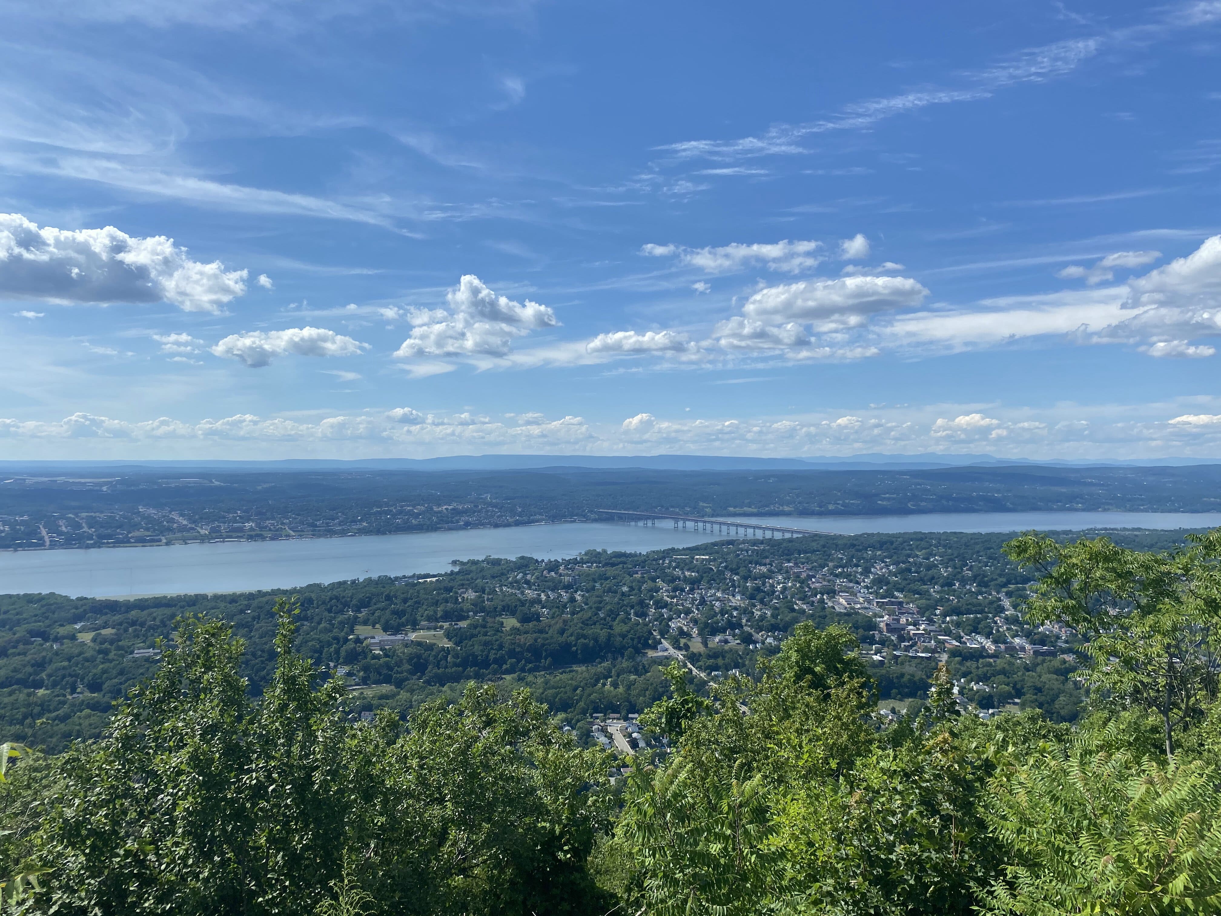
The Beacon Summit offers fantastic, clear views of the Hudson River, the Newburgh-Beacon Bridge, and the City of Beacon. Across the river you can spot the City of Newburgh and Mount Saint Mary College, as well as see flights coming and going from Stewart International Airport.
Again, it was about an even mile from the parking lot to this summit, meaning turning around now would result in a two-mile hike with about 1,000 feet of elevation gain.
From here you would have three main options to extend the hike further:
I’ve technically done all three. I usually go until at least the Mount Beacon Fire Tower whenever I hike Mount Beacon. I completed the Wilkinson Memorial Trail Loop and it was a fun time. And while I’ve never actually traveled South from the tower on a day where I parked in Beacon, I’ve done the opposite: parked at Breakneck Ridge and reached the Fire Tower in a one-day loop.


The path on the red Casino Trail meanders on mostly level ground for the start of this extension. Less than 400 feet of elevation is gained in 1.4 miles. So while the first part of the hike had a gain of 980 feet per miles, this part of the hike only averages 285.7 feet of elevation gain per mile.
In other words, if you have energy left in the tank, this extension is worth the trip to the Fire Tower.
The path to the Fire Tower does veer slightly off the red trail, and I almost missed it. Luckily I was redirected by a fellow hiker, who could tell I was a little confused. An uphill trail through some small then large rocks opens up on the right, and as I far as I can tell, it’s the only way to get to the Fire Tower from this side of the mountain, even though it briefly leaves the marked trail.


Scaling the Mount Beacon Fire Tower is optional, and not for the faint of heart. Climbing up the metal stairs on a windy day and seeing the rocks below you can be a scary feeling. But if you’re coordinated enough and can trust yourself going up the stairs, the views are incredible.
The 360-degree view offered at the top of the Fire Tower offers a larger but slightly more distant view of the Hudson River. Slightly to the North East there’s a reservoir, and looking to the South you can see more of the Hudson Highlands. On a clear day, New York City is visible to the South with the naked eye.


I measured 1.4 miles from the Beacon Overlook to the Fire Tower for a total of 2.4 miles from the parking lot. While the initial ascent can be a challenge, the mileage on this hike gives you an incredible “bang for your buck.”
On a fair-to-nice day of weather, or on any weekend from Spring to Summer and even Autumn, the base of the the Fire Tower is likely to be bustling with hikers, families, dogs, and picnics. The most common way to reach the Fire Tower is the trail I just followed, while some more adventurous hikers may have come from Southern trailheads such as Breakneck Ridge or the Wilkinson Memorial trail.
On this day I reached the Fire Tower just an hour and five minutes after leaving my car in the parking lot. Since I’ve done this hike a few times, I didn’t really stop to smell the roses along the way, and spent just ten minutes at the Beacon Overlook. If you’re hiking Mount Beacon for the first time, I would definitely recommend setting aside more than a couple hours, in order to fully appreciate this beautiful hike.
I spent about half an hour in and around the Fire Tower. I had about 15 minutes of solitude at the top of the Fire Tower, a rare treat in the summer time. It was a Friday afternoon, and not until I was getting ready to leave did I see another group of hikers approaching the tower.

Curiously, Apple Health only measured 2.1 miles on my decent, compared to 2.4 miles on my ascent. It could probably be chalked up to taking a couple steps off trail to see things on my way up, as well as a lit bit of technical error. I covered this alleged 2.1 miles in 41 minutes from the Fire Tower to the parking lot, not making any additional stops.
In total, and putting faith in the Apple Health app, this hike covered 4.5 miles over two hours and 16 minutes of real time, and one hour and 36 minutes of hiking if you exclude breaks at the Beacon Overlook and Fire Tower.
I highly recommend this hike, including the Fire Tower, to anyone who is able-bodied and finds themselves with time to hike in the Hudson Valley.


