An anticipated polar vortex, coupled with some potential wintery precipitation, is expected to create frigid conditions in the greater Denver area as well as Colorado and many of the surrounding […]
An anticipated polar vortex, coupled with some potential wintery precipitation, is expected to create frigid conditions in the greater Denver area as well as Colorado and many of the surrounding states from January 12 to January 15, encompassing Dr. Martin Luther King Jr. Day Weekend.
This post will serve as ongoing coverage of the weather conditions reported and how they affect Denver residents, before being archived into a summary and historical record of the events.
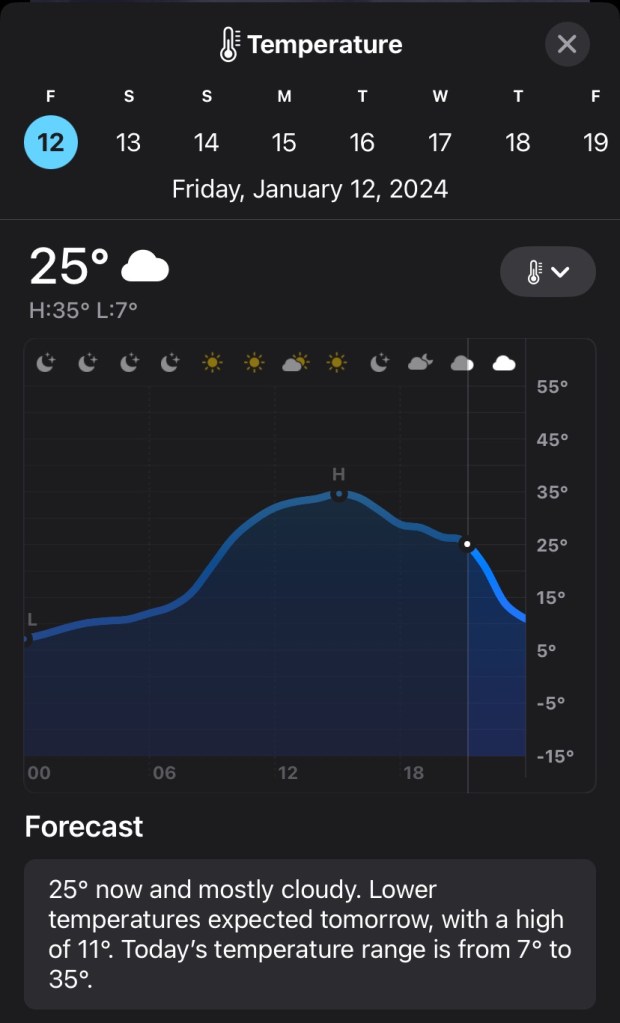
Friday morning was frigid in South Denver, with a temperature of 14 degrees at 7:19AM sunrise, with a wind chill/”feels like” of 5 degrees, per Apple Weather. But by a little after 2:30PM, it was sunny and 35 degrees with a wind chill of 28 degrees: hardly anything unseasonal or notable for Denver, Colorado in mid-January. Still, it was colder than it had been over the course of the second week of January: with temperatures approaching and even topping 50 degrees earlier in the week.
But anyone who thought this was the infamous cold front coming in was in for a rude awakening. As the sun set in Denver Tech Center at 4:57PM, the temperature was 31 degrees with a wind chill of 24 degrees: again, on a day with fair skies in January, hardly anything to complain about.
However, the cold front from the North was looming just overhead. The cold front’s arrival, coupled with the sunset, made the temperature drop 24 degrees in just 40 minutes in Cheyenne, Wyoming due North of Denver by 5:08 PM. The cold experienced in Denver up until this point was merely seasonal: the cold front, which was predicted weeks out, was about to arrive.
Cheyenne, WY just dropped 24° in 40 mins as the cold front moved through (25° to 1°) .
As I jotted down my own data for the first time, it was 27 degrees with a wind chill of 19 degrees at 6:39PM as I settled in to my apartment after a full day of work. Just 20 minutes earlier, the Boulder National Weather Service echoed a similar sentiment about the cold front:
The arctic cold front is pushing through the northern plains & I-25 corridor now, and is on Denver's doorstep. Expect a rapid drop in temperatures of approximately 20-25 degrees in < 1 hr as it comes through, along with below-zero wind chill. Map shows current temps #COwxpic.twitter.com/coGpWiuG9l
At 8:16 PM it’s still 25 degrees at home, a mere 2-degree drop in a little over an hour-and-a-half. But at this hour, the cold front could strike at almost any minute. For a preview of what’s to come, Denver International Airport experienced a 16-degree drop in 13 minutes around 7:40PM, with temperatures dropping from 30 to 14 degrees in less than a quarter-hour.
Temp just dropped 16° in 13 mins @DENAirport. 30° to 14°.
I stepped out around 8:20PM to get some Illegal Pete’s for dinner. When I returned to my apartment at 8:50PM, the harsh cold appeared to be imminent. Most notably, my car’s external temperature reading dropped from 26 degrees to 14 degrees during my 6-minute car drive home. Official readings on both Apple Maps and Weatherbug offered a 2-degree drop at most, so take the car’s reading with a grain of salt, but the cold was definitely here in the Southern tip of Denver. Most notably, the wind obviously picked up, adding harshness to the cold.
But according to whichever station (will try to pin down) we’re pulling data from, the actual drop was still minutes away, with a 25 degree/18 degree wind chill recorded at 9:07PM.
While consistency is key and I’ll keep checking my Apple weather to compare readings, my computer’s built-in Microsoft Weather app seems to be displaying a potentially more location-accurate 22 degrees/14 degree real feel at 9:22PM, while Apple shows 25/16. Microsoft lets me pin my exact location, but with no weather station at my apartment, that information is unfortunately not 100% reliable either.
9:33PM: We have movement! Apple finally down to 24 degrees, 14 degree wind chill. Though not reported, flurries flying through the wind, as stepping outside even for a moment tingles the spine. Real snow is quite possible overnight, with one-to-four inches expected.
9:30pm: Snow mainly over Larimer/Weld Counties right now, but it’s slowly pushing south.
9:39PM: We’re moving now. 23 degrees/13 degree wind chill. Winds 9 mph with gusts up to 16 mph. At this point, I can feel the cold seeping through my window/wall near my laptop.
9:53PM: Down to 21 degrees/10 degree wind chill. Winds continuing to increase at strength, now at 10 mph/17 mph gusts.
10:00PM: 20 degrees/9 degree wind chill. Winds 10mph/17mph gusts. Officially on “Flurries” now on Apple. Every breathe is visible. The sky, which once showed a couple stars, is now cloud-covered.
10:10PM: 19 degrees/7 degree wind chill as we continue to drop. Winds sustained at 10/17mph.
10:21PM: 18 degrees/6 degree wind chill. The gap is narrowing between Apple and Microsoft, which now offers 15 degrees/6 degree wind chill.
10:30PM: 17 degrees/5 degree wind chill. If it wasn’t apparent by now, we’re not getting quite as drastic numbers here in DTC as Cheyenne and DIA got, but they’re still moving. The mountains halt the progress of the cold front, so naturally, the front swept the open plains easier than the parts of Denver nestled closer to the elevation changes. If anything, this looks like the fastest-moving period yet, with 14 degrees possible in the next 25-30 minutes.
Checking in on Greeley, Colorado shows the plains to the North getting frigid real quick: -2 temperatures with -24 wind chill.
8 degree drop from 9:39PM to 10:49PM (1 hour and 10 minutes) from 23 degrees to 15 degrees in Denver Tech Center
1 degree drop every 8.75 minutes. No where near as drastic as nearby DIA or Cheyenne to the North, but it’s falling. #COwx#wx
— Sakmann News Entertainment & Sports (@SNESBlogs) January 13, 2024
10:53PM: 15 degrees/2 degree wind chill. Winds peaking at 11mph with 17th gusts: the winds that brought the cold front in tonight should be the harshest winds Denver experiences all week.
11:10PM: 12 degrees/-2 degrees wind chill. Really falling now as deep night starts to begin. Flurries gently set in again.
11:30PM: 11 degrees/-2 degrees wind chill, drop off has slowed again. It’s currently 8 degrees in downtown Denver and 5 degrees in Boulder: DTC isn’t getting the brunt so far.
Saturday, January 13
An Arctic Cold Front that blasted through Northeastern CO. last evening brought light snow & frigid cold temperatures to much of the forecast area. Overnight lows dropped well below zero across much of the plains overnight with dangerous Wind Chill reading as low as -40 F. #cowxpic.twitter.com/ffsNdvoHYN
7:35AM: Just waking up for the day, and it’s the lowest temperature we’ve seen yet by far. -8 degrees actual/-21 wind chill. According to the forecast, this is the coldest it will be today, and possibly all weekend: no day is forecast to have temperatures under -7 degrees after today. Checking in on conditions at DIA, it’s even colder.
Currently -11° @DENAirport, ties the coldest temperature there since the Dec. 2022 plunge.
-32° wind chill right now also. Frostbite can develop in 10 mins.
10:11AM: Shifting to Highlands Ranch/Lone Tree, the area where I work, the temperature is now -4 degrees with a wind chill of -14 degrees. The wind itself is nothing crazy: 4mph with 8mph gusts. The front doors to my store don’t close, so that’s been fun, with cold seeping in to store.
3:21PM: Back home in DTC, 5 degrees (the high for today) with a -5 wind chill. The next 20 minutes or so is the warmest that temperatures are expected to reach all day. Skies have been mostly clear with scattered clouds. It took forever to warm up today, struggling to crack 0 degrees in some areas.
In my years of forecasting here in Denver – these arctic air masses are almost always under forecast by a good 5 to 10 degrees. It’s noon and we are still all well below zero in the metro area. #COwxpic.twitter.com/71KjbX9LH7